A Missed Crosswalk. A Fast Car. A Death. This Is What Traffic Violence Looks Like in Roanoke.
Gary Wayne St. Clair, 63, crossed Campbell Avenue on a Thursday night in May. The driver stayed. The road stayed. Nine days later, only St. Clair was gone.
Roanoke, VA
Author: Roanoke Rambler Staff
Published: 7:30 AM EST June 3, 2026
Edited: 7:30 AM EST June 3, 2026
Just after 10 p.m. on a Thursday night in May, Gary Wayne St. Clair tried to cross Campbell Avenue in southeast Roanoke. Nine days later, he passed away.
Police say St. Clair, 63, stepped into the 600 block of Campbell Avenue SE around 10:11 p.m. on May 9th and was hit by a passing vehicle. He was rushed to the hospital with life-threatening injuries and died on May 18th. The driver stayed at the scene and, according to investigators, St. Clair was outside a crosswalk when he entered the road.
Campbell Avenue isn’t an abstract line on a map. It’s a place where people live, work, and walk because they have to. Even late at night, it’s the kind of corridor where a missed bus, a late shift, or a quick trip to a store can put you next to fast-moving traffic with few good options for crossing.
The key details in St. Clair’s case are depressingly familiar: a busy arterial, a nighttime crossing, a person on foot outside a marked crosswalk. If you only read the police report, you might conclude the lesson is simple: people should use crosswalks. But spend time on Campbell, Peters Creek, Williamson or some downtown intersections after dark, and the story looks different. Crosswalks can be far apart. Lighting can be poor. Sidewalks can disappear or be blocked. Waiting for the “right” place to cross can mean walking an extra quarter-mile along the edge of a road that already feels hostile to anyone not encased in metal and glass.
That’s not an excuse. It’s context. And for people who walk because they have no car, no license, or nowhere stable to go, that context is the difference between a “bad choice” and a survival calculation.
St. Clair’s case underscores something advocates have said for years: traffic violence doesn’t fall evenly.
Older adults, people with disabilities, low-income residents, and those without stable housing are more likely to be out on foot, often at off-hours, often in places where the infrastructure wasn’t designed with them in mind. A missed bus, a closed shelter door, a late shift, or a last-minute errand can put them on the shoulder of a road at 10 p.m., not on a leafy greenway at 5pm in the afternoon.
Roanoke City’s safety initiative of vision zero – zero fatal car accidents continues after being adopted in 2020. Roanoke also has the “Slow Your Roll” traffic-safety campaign, which pushes drivers to ease off the gas, put phones away, and watch for people walking or biking. The campaign members recently had an event earlier in May. There are accessibility and safety upgrades at problem intersections, such as work along Campbell and in parts of downtown to widen sidewalks, improve curb ramps, and tighten turning radii so vehicles take slower, safer paths.
On corridors like Williamson Road, the city has tried more aggressive measures: road diets that remove travel lanes, add a center turn lane, and are meant to lower speeds and crash severity. Those moves are rooted in decades of research: narrow lanes and fewer conflict points usually mean fewer severe crashes.
Some changes are not without complaints. Drivers complain about congestion and lost lanes. Business owners worry about access. Some residents see enforcement as revenue-driven harassment, not safety.
Roanoke is not unique in this regard. Cities across the country are grappling with rising or stubbornly high pedestrian fatalities even as vehicles get safer for the people inside them. The pattern is familiar: bigger cars, faster speeds, more distraction, aging infrastructure.
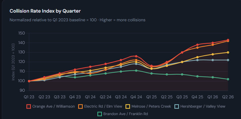
A 2025 review by a Roanoke-area injury firm, drawing on Virginia crash data, identified these as the five most dangerous intersections for auto accidents in Roanoke:
- Orange Avenue & Williamson Road
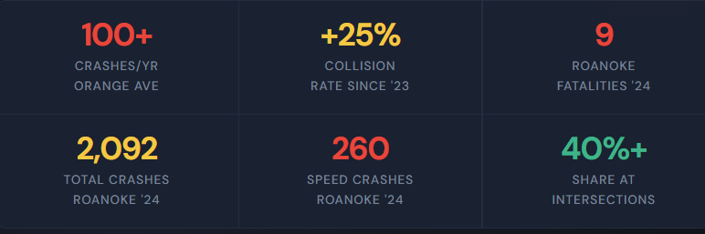
- 100+ crashes per year
- Major east-west and north-south arteries meeting at a busy, signalized junction.
- High volumes, multiple lanes, turning movements, and speeding contribute to frequent collisions.
- Orange Avenue in particular has seen about a 25% increase in collision rates since 2023.
- Hershberger Road & Valley View Boulevard
- Key access point to the Valley View Mall/retail area, with heavy shopping, restaurant, and interstate-adjacent traffic.
- Constant turning movements and congestion make rear-end and angle crashes common.
- Peters Creek Road & Cove Road
- Busy suburban arterial intersection serving both neighborhood traffic and through-trips.
- Speed and complex movements are cited as recurring safety challenges.
- Brandon Avenue & Franklin Road
- A major crossroads in southwest Roanoke, linking residential areas, commercial strips, and commuter traffic.
- Frequent congestion and turning traffic raise crash risk, especially at peak times.
- Melrose Avenue & Salem Turnpike
- Heavy-use corridor in northwest Roanoke where neighborhood traffic meets a major thoroughfare.
- Speeding and red-light running have been longstanding concerns here.
These are not the only dangerous spots, local drivers also regularly point to places like the Elm Avenue off-ramp from I-581, the Brandon & Grandin area by Patrick Henry, and parts of Williamson and Electric Road as high-stress, crash-prone locations. The five above consistently show up in data-driven lists as places residents should be cautious about.