
Roanoke's Drought Is Getting Worse
While the rest of Virginia's drought map turns from red to yellow, one number keeps sinking: the water level at Carvins Cove.

While the rest of Virginia's drought map turns from red to yellow, one number keeps sinking: the water level at Carvins Cove.
Roanoke, VA
Author: Roanoke Rambler Staff
Published: 12:47 PM EST August 19, 2026
Edited: 12:57 PM EST August 19, 2026
Walk the shoreline at Carvins Cove this month and you'll see it before anyone tells you: a wide, cracked band of exposed lakebed where water used to be. Longtime visitors say they haven't seen it this bad in years. They're right and the state's own water managers say it's still getting worse.
Here's the number that should worry you more than any drought map: in mid-June, Carvins Cove sat 13.4 feet below full pond. By mid-August, it had sunk to roughly 17.5 feet below — a four-foot drop in two months, despite rain falling in the meantime (City of Roanoke). Normal weather stopped being enough to fix this months ago.
The two-ruler problem
Virginia's drought map has been getting better almost everywhere. Statewide, extreme drought conditions collapsed from 26% of the state in mid-July to just 0.3% by mid-August. Richmond, the Tri-Cities, even parts of the New River Valley, have climbed out of drought status entirely.
Roanoke hasn't. Since Virginia's Drought Monitoring Task Force declared a formal drought emergency, the most severe tier in the state's response plan, for the Roanoke Drought Evaluation Region on July 7, that status hasn't budged, even as the statewide map improved twice in August (Governor of Virginia). Governor Abigail Spanberger exclaimed in a press release sent to the Roanoke Rambler that “increased water conservation measures are critical to protect access to adequate water supplies for Virginia’s families, farms, and communities as the drought persists.
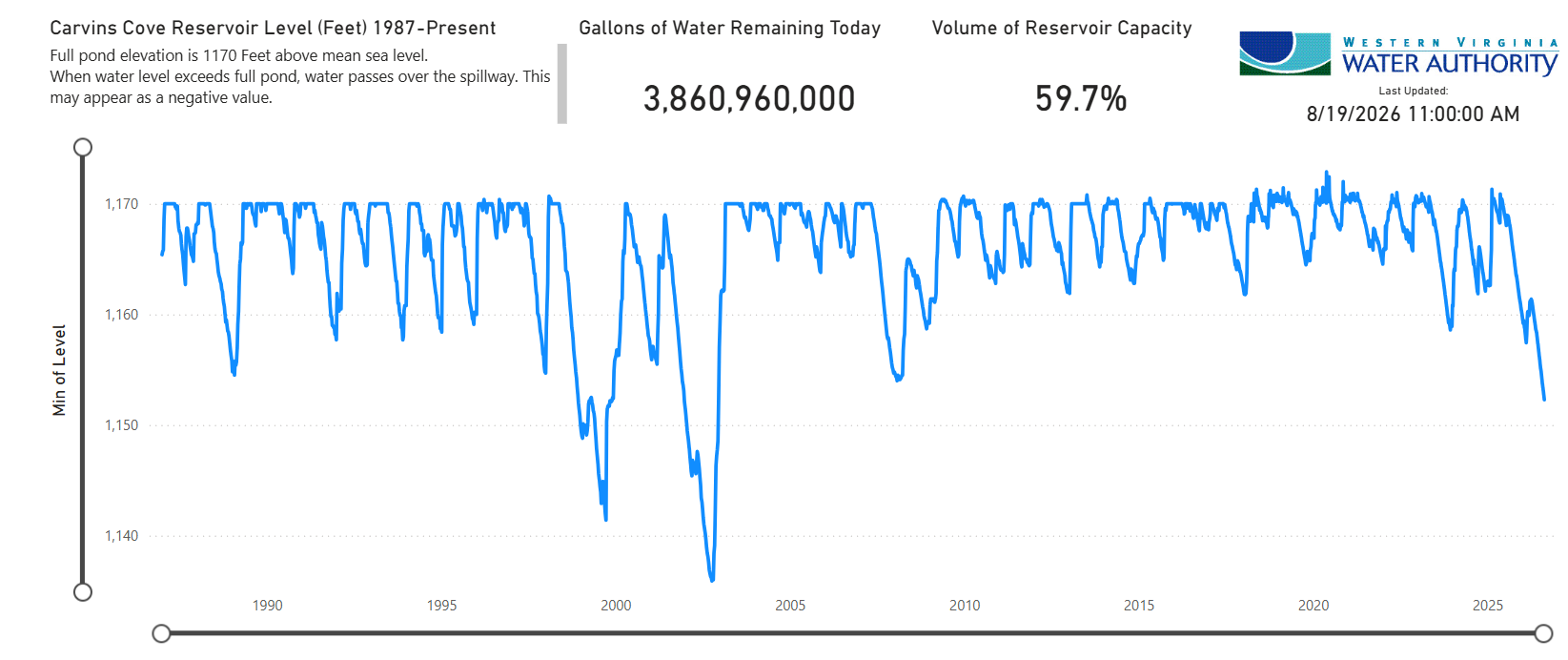
Why the disconnect? Two different rulers are measuring the same drought. The U.S. Drought Monitor, the map you've probably seen, now technically classifies Roanoke as just "moderate" drought. But that's not the ruler Virginia uses to decide whether to shut off your sprinkler. The state's own regional evaluation, streamflow, groundwater, soil moisture, reservoir levels combined, has kept Roanoke locked in emergency status since July 7. That's the ruler that determines whether mandatory restrictions land on your street. And it hasn't moved.
The bottom line: the region has received only 57% of its normal rainfall for this point in the year, and is sitting on a roughly nine-inch rainfall deficit since January (Governor of Virginia).
Not 2002 yet — but running the same script
Roanoke has been here before, worse. In October 2002, Carvins Cove hit its all-time recorded low — 1,135.9 feet, just 31.8% of capacity (Western VA Water). Today's level, while alarming, is nowhere near that. But the pattern is unnervingly familiar: both the 1998-99 and 2001-02 droughts sank through summer and were only resolved or worsened into multiyear crises by what happened the following winter. Nobody will know which version of 2026 this is until the snow does or doesn't fall.
One thing genuinely is different this time: the water system itself. The 1999 and 2002 crises were bad enough to force Roanoke's city and county water systems to merge into today's unified Western Virginia Water Authority. That integration is paying off right now, sister reservoir Spring Hollow is holding at 80.1% capacity, well ahead of Carvins Cove's 68.9%, because it draws from the Roanoke River rather than rainfall runoff alone. "Having Spring Hollow, Carvin's Cove and some of our groundwater sources gives us water supply in different geographic locations... it gives us some better drought protection," Water Authority spokesperson Sarah Baumgardner said in a media release.
The new fight nobody had in 2002: data centers
This drought is colliding with a decision Roanoke City leaders are making right now, new rules governing data centers before developers even show up. The math shows why that timing matters:
- Google has already reserved up to 2 million gallons a day from Carvins Cove, 730 million gallons a year at full contract (Water Authority Releases Google Data Center Records Ahead of Scheduled Contempt Hearing)
- Run that draw for a full year under current conditions, and Carvins Cove falls from 68.9% to 58.4% capacity.
- Stack that same draw on top of a 2002-level drought, and the reservoir would sit at roughly 20.4% capacity, genuinely dangerous territory.
Water officials note this isn't happening in a vacuum — Falling Creek Reservoir, once back online from dam repairs, would cover 72.5% of Google's daily need on its own, and Coca-Cola already draws 260,000 gallons a day locally for flavored water according to water records. But the underlying question doesn't go away: who gets priority access to a shrinking resource, decided at the exact moment the city is writing the rules for how many more data centers get to ask for it.
The damage you can't see from the shoreline
While reservoirs make headlines, the deepest cuts are running through farmland out of view. The USDA has issued drought disaster designations covering every locality in the Roanoke evaluation region. Franklin County cattle and hay producer Scott Sink, president of the Virginia Farm Bureau Federation, put it bluntly: "We already have producers that are having to truck hay in from states outside of this region" said to the media. The full scale of crop losses won't be known until fall harvest, a number worth watching for. Farmers under the strain can call the AgriStress helpline: 833-897-2474.
What could actually change this and what you can do now
Restrictions on households remain voluntary for now: water outdoors before 10 a.m. or after 7 p.m., fix leaks, run only full loads. That could change fast. If Virginia declares a formal emergency executive order, mandatory rules would ban lawn and golf-course irrigation, car and driveway washing, ornamental fountains, and pool refills, and force industrial users to cut back (Governor of Virginia).
Want to see the numbers yourself before deciding whether to worry? The Water Authority is holding a public water-supply open house Tuesday, Aug. 25, 4-7 p.m., at its Field Operations Building, 3322 Hollins Road NE (Western Virginia Water Authority).
Whether this becomes a footnote or a defining crisis for the Roanoke Valley comes down to something nobody here controls: what the sky does between now and spring. A single tropical system changed everything in 1999. A dry winter made 2002 historic. Right now, nobody not the Water Authority, not the state, not this newsroom, can tell you which one is coming.
We'll be tracking the reservoir levels, the data-center rules, and the harvest numbers as they come in. If you want to know before it becomes a headline elsewhere, subscribe to the Rambler.